
IAEA Establishes Lake Isotope Network: Water Levels Are Dropping—How to Determine Whether It Is Evaporation or Reduced Inflow?
 Scan to share
The same drop in water level can mean a lake is losing water from different sources
A water gauge can record how much the lake surface has fallen, but it is difficult for the reading alone to tell managers where the water went. Sustained high temperatures increase evaporation, lower upstream precipitation reduces river inflow, and basin water withdrawals and groundwater exchange can also alter lake water volume. Several of these processes may occur simultaneously. To decide whether to prioritize adjusting upstream water withdrawals or strengthening dry-season water supply reserves, it is necessary to know which change has the greatest impact on lake water volume.
On November 3, the International Atomic Energy Agency (IAEA) announced the establishment of the Global Network of Isotopes in Lakes (GNIL). The network plans to bring together stable isotope, water chemistry and environmental observation data. Initial work includes harmonizing sampling methods, organizing coordinated sampling and establishing data-sharing arrangements. Twenty-two countries have already expressed interest in participating. This figure reflects intent to participate. Whether the network can accumulate comparable long-term data also depends on whether members can consistently implement the same set of sampling and quality control requirements.
Evaporation alters the ratio of heavy to light water molecules in lake water
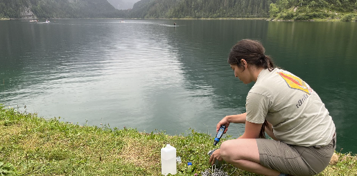
The hydrogen and oxygen in water molecules each have different isotopes. Deuterium is the heavier stable hydrogen isotope, and oxygen-18 is heavier than oxygen-16. When evaporation occurs at the water surface, lighter water molecules generally enter the air more readily, so the water remaining in the lake becomes relatively enriched in heavy isotopes. Such natural compositional variations can be measured in the laboratory. Stable isotope analysis uses the compositional differences that already exist in water, and field work typically begins with collecting samples of lake water and its potential inflow sources.
The composition of the inflow itself also changes. Rainfall source, season and altitude can all affect the hydrogen and oxygen isotope ratios. Groundwater may integrate recharge from rainfall over a longer period, and rivers may mix water from different tributaries. A single measurement showing an increase in the heavy isotope ratio of lake water needs to be interpreted together with concurrent rainfall, inflow rivers and possible groundwater inputs. If evaporation intensifies, lake water tends to show evaporation enrichment characteristics relative to inflow. If the inflow source changes, changes in lake water may partly inherit the composition of the new input. The two signals sometimes superimpose, and continuous observation is needed to distinguish them.
Whether data can be used across lakes depends on how clearly sampling conditions are documented
A deep lake may form thermal stratification in summer. The lake surface is directly affected by evaporation, while deeper water layers may exchange less with the surface layer for a period. If site A samples only the surface layer in summer and site B samples during winter turnover when the whole lake is mixed, the two datasets represent different water bodies even if the analytical instruments are completely identical. A multinational network must record sampling location, depth, date, water temperature and hydrological conditions at the time. Only when this information is complete can researchers know whether two records can be compared together.
Practical assessment also requires combining water balance. Precipitation and inflow enter the ledger, while evaporation, outflow and withdrawals leave it, and water level and lake basin morphology reflect changes in storage. Stable isotopes add source and evaporation information to this ledger, while hydrological stations, meteorological stations and withdrawal records provide independent constraints. If groundwater recharge is difficult to measure directly, researchers can use multiple candidate scenarios to find explanations that simultaneously match water balance and isotope observations. Being able to rule out some explanations is sometimes enough to change the placement of sites for the next round of investigation.
The network's first achievement should be verifiable dry-season records
A dataset with management value should be able to explain how the composition of lake water and inflow changed before and after the dry season, how much of the water level decline can be explained by changes in evaporation and inflow respectively, and where the remaining uncertainty comes from. For water supply agencies, what is truly useful is using this to determine whether the next step should be additional groundwater measurements, verification of withdrawal volumes, or reassessment of evaporation losses in high-temperature years. Only if different regions can verify these conclusions using the same methods does cross-lake monitoring have practical decision-making value.
(This article is independently written after AI-assisted organization based on the IAEA's network launch index and project information, and the network description published by the American Nuclear Society. The examples in the text are used to explain stable isotope hydrology; attribution for a single lake requires on-site monitoring and water balance verification.)
Disclaimer: Information republished from partner media, institutions or other websites is provided for reference and communication purposes only. It does not imply endorsement of its views or verification of its accuracy. Please contact us if any content infringes rights or requires correction.